Using MT Technologies For Rapid, Cost Effective and Accurate Geothermal Resource Detection
MT exploration provides important data for locating and exploiting these valuable resources, in an environmentally friendly, reliable and cost-effective way
Geothermal energy is one of the Earth's largest energy sources, creating clean, low-cost electricity for millions of people around the world.
Phoenix Geophysics is a world leader in the development and application of MT for geothermal resource exploration. Using real-time, remote-reference processing techniques, Phoenix has acquired top-quality data and pinpointed the location of geothermal sources around the world. Exploration has been carried out both in high noise environments close to existing geothermal power plants and in greenfield exploration in rugged and remote areas with high levels of cultural noise. Examples are Hatchobaru, Japan, Negros Island in the Philippines, and Runion Island in the Indian Ocean.
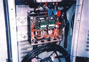
llustrated: A geothermal reservoir monitoring system installed in Japan

Block diagram of the system, which is scalable up to 64 channels.

Solar powered remote reference station.
Standard data acquisition unit with dial-up modem for data transmission by telephone line or radio telemetry.

Automated processing computer in central hut.

Monitoring station installed in forested area.

Left: Fibre optic and DC power cables.
Right: monitoring unit in all weather metal enclosure.
Many geophysical and geological processes (natural and man-made) cause variation of the earth's physical properties with time. Examples of natural processes include volcanic eruptions, earthquakes, landslides, and hydrological variations. Man-made processes usually involve movement of fluids in the zone of interest. Such zones include geothermal or hydrocarbon reservoirs; injection wells; underground storage caverns for natural gas or other substances; and producing aquifers.
By monitoring these physical properties over time, the nature of their temporal and volumetric variations can be defined. The resulting knowledge can be used to optimize production processes or to help forecast volcanic eruptions and earthquakes, for example. The main physical property measured by this system is resistivity. Significant resistivity variations are typical in all the applications mentioned. With Phoenix monitoring equipment and software, the changes can be measured at the surface. The system features fully automated power supply, data acquisition, and data processing, so manpower requirements are reduced to the minimum. Researchers or operators access key results as graphs, maps, and volumes showing the variation of parameters with time.
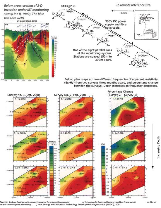
4-D MT Geothermal Reservoir Monitoring in Japan
Deep Rapid Reconnaissance and Detailed Follow-Up
From near-surface down to any practical drilling depth and beyond, MT allows rapid reconnaissance of areas as large as tens of square kilometers, while detecting conductive zones to 2000 m and deeper.
Closely spaced stations along lines or nets provide data redundancy, high lateral resolution, and a continuous picture of the subsurface resistivity structure.
In a two-pass methodology, station and line spacing are as wide as possible in the first pass to keep cost to a minimum. Once areas of interest have been identified, a second pass with more stations at closer spacing increases resolution. The result is rapid, accurate, and cost-effective identification of conductive mineralized zones.
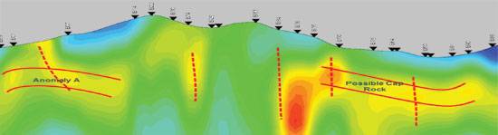
Rapid, Cost-Effective Mapping Of Conductive Zones
Equipment weighs only 30 kg per site, so it's portable by backpack, ATV, snowmobile, or helicopter, from tundra to jungle, in any season. This logistic simplicity reduces cost and increases productivity.
The small footprint and environmentally benign installation make the technique practical almost anywhere.
Flexible site location and offline sensitivity allow meaningful profiles to be constructed without the rigid grid of methods like seismic and IP.
Induction vectors indicate the direction and relative strength of offline conductors and are especially useful where the surface is resistive or frozen (no electrodes required).
MT/AMT sees through the thick conductive clay (impenetrable by airborne or other surface techniques) that covers many prospective areas.