Access to GIS mapping solutions that are optimised for earth exploration, enables greater precision in interrogating geoscientific datasets, and obtaining 3D insight of the Earth's subsurface. With more efficient tools for creating and sharing maps and interpretation results, within ArcGIS, organisations can improve targeting effectiveness and reduce uncertainty for greater discovery success.
Target for ArcGIS
Subsurface Geology for ArcGIS

Geosoft has made it easier for earth explorers working within Esri ArcGIS. Explorers can visualise drillhole and borehole geology data and quickly integrate it with their exploration data without leaving their ArcGIS environment. Tight integration between Geosoft and Esri ArcGIS, with ArcEngine built-in to the Geosoft platform, ensures easy sharing of data, results and knowledge between both exploration and GIS environments.
Overview Target for ArcGIS:
Integrate borehole positions with geology, geochemistry or geophysics data through plan, profiles and section map views.
Recreate sections and plans with a few mouse clicks.
Automate legend generation, including lithology patterns.
Present geological, geochemical, geophysical and geotechnical data in a single graphic display.
Create up to 32 logs with data and graph type selections in each plot.
Display your data in 3D with drill traces, surfaces and 3D models.
Generate surface grids using robust methodology such as minimum curvature, kriging, and tinning.
Enhance surface mapping with interval and exact level contouring.
Generate a voxel (3D grid), incorporating the strike, dip and plunge from your geology.
Display isosurfaces from your voxels.
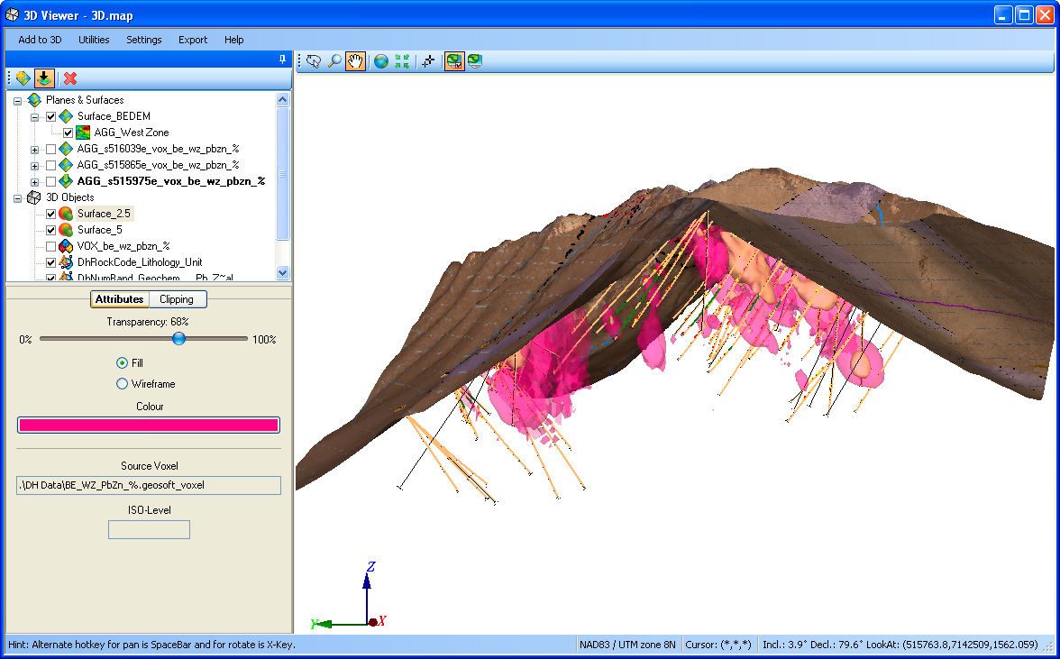
Subsurface 3D Tools

Integrate all data in one environment
Recommended hardware and software requirements for Target for ArcGIS 3.5.1
Operating System
Windows 7 SP1 (32-bit and 64-bit) - Recommended.
Windows Vista Business SP2 (32-bit and 64-bit).
Windows XP Service Pack 3 (32-bit) - Minimum requirement.
ArcGIS Version
Requires ArcGIS 9.3.1 (SP2), ArcGIS 10 (SP5) or ArcGIS 10.1
CPU
A Dual Core processor is recommended. An Intel Celeron processor is not recommended.
RAM
4-8 GB recommended, 1 GB minimum required.
Graphics
Nvidia Professional 256MB 3D (OpenGL 2.0) Graphics Card recommended.
Printer/Plotters
Any Windows supported colour printer. Hewlett Packard large-format ink-jet plotters are recommended.
Installation Permissions
When installing ArcGIS Extensions, you MUST be logged on with Administrator permissions.
Installation Disk Space
2 GB or more of free space on the Program Files drive is required for the installation process.
Data Disk Space
Data disk space depends on the volume of project data to be processed and the printer driver you are using, however 100 GB is recommended. This is largely based on your business and data requirements.
Internet
To use the internet capabilities in your Geosoft software, you will need to install Internet Explorer 7.0 or later. This does not mean that you have to have Internet Explorer as your default browser; the Geosoft software applications just use the internet connection technology supplied in IE7.
Supporting Software
The following software prerequisites are required and will be downloaded and installed if not present: Microsoft .NET 4
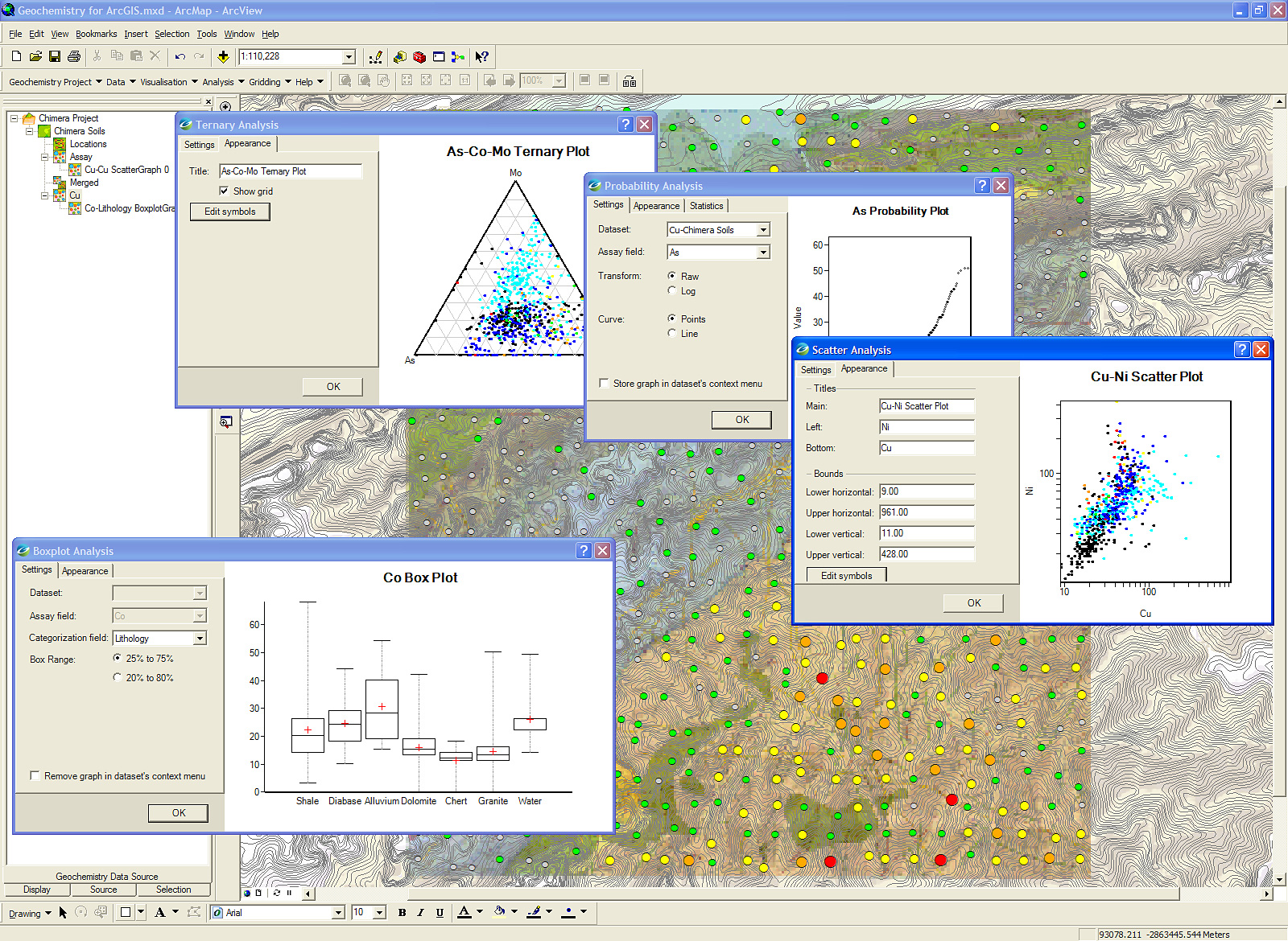
Geochemistry for ArcGIS
Exploratory Geochemical Data Analysis
Geosoft Geochemistry for ArcGIS builds on the success of our subsurface geology extension, Target for ArcGIS, and provides you with the ability to organise, ensure quality control, visualise, and analyse geochemical data within the Esri ArcGIS environment.
Overview Geochemistry for ArcGIS:
Simplify your geochemistry quality control process and maintain data in an Esri file geodatabase using a data model optimised for geochemical data.
Select and subset data interactively from maps based on lithology and regions to enhance data display.
Create advanced geochemical maps within the Esri ArcGIS Desktop environment.
Analyse multi-element geochemistry using interactive multiple histogram plots, Pearson's correlation reports, scatter plots, probability plots, ternary plots and box plots, to identify outliers and define populations.
Import data from several different sources and file types.
Statistical Data Analysis
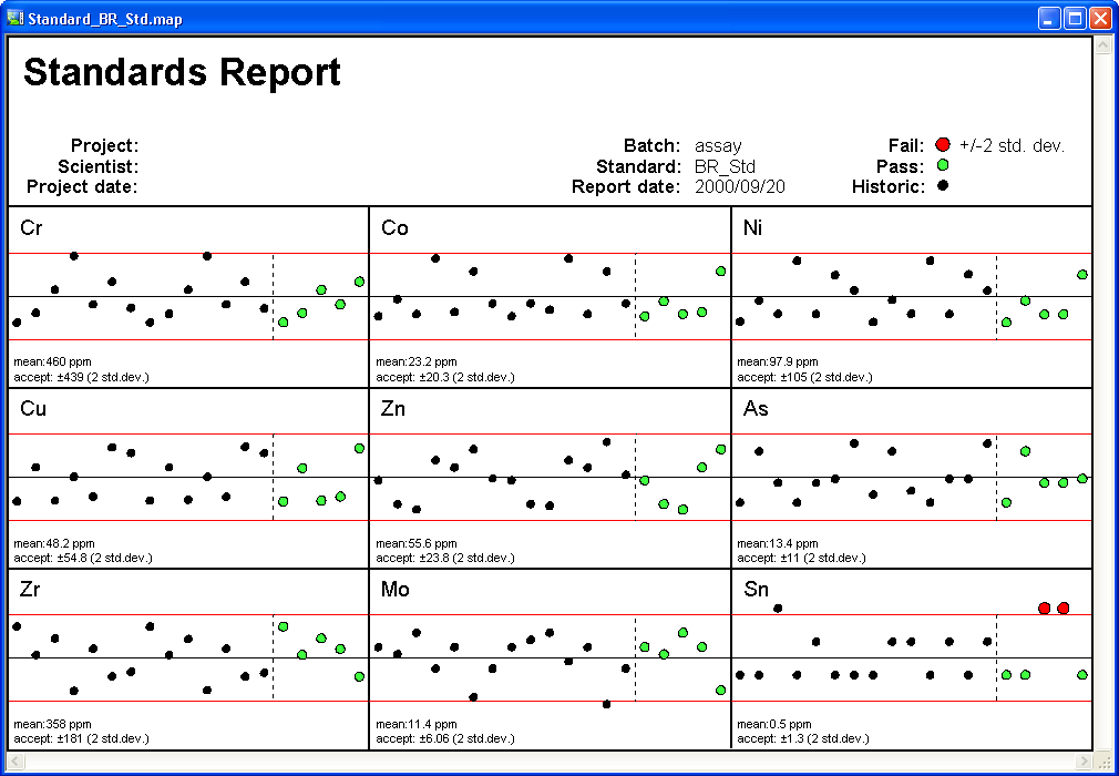
Quality Control
Recommended hardware and software requirements for Geochemistry for ArcGIS 3.5.1
Operating System
Windows 7 SP1 (32-bit and 64-bit) - Recommended.
Windows Vista Business SP2 (32-bit and 64-bit).
Windows XP Service Pack 3 (32-bit) - Minimum requirement.
Operating System
Windows 7 SP1 (32-bit and 64-bit) - Recommended.
Windows Vista Business SP2 (32-bit and 64-bit).
Windows XP Service Pack 3 (32-bit) - Minimum requirement.
ArcGIS Version
Requires ArcGIS 9.3.1 (SP2), ArcGIS 10 (SP5) or ArcGIS 10.1
CPU
A Dual Core processor is recommended. An Intel Celeron processor is not recommended.
RAM
4-8 GB recommended, 1 GB minimum required.
Graphics
Nvidia Professional 256MB 3D (OpenGL 2.0) Graphics Card recommended.
Printer/Plotters
Any Windows supported colour printer. Hewlett Packard large-format ink-jet plotters are recommended.
Installation Permissions
When installing ArcGIS Extensions, you MUST be logged on with Administrator permissions.
Installation Disk Space
2 GB or more of free space on the Program Files drive is required for the installation process.
Data Disk Space
Data disk space depends on the volume of project data to be processed and the printer driver you are using, however 100 GB is recommended. This is largely based on your business and data requirements.
Internet
To use the internet capabilities in your Geosoft software, you will need to install Internet Explorer 7.0 or later. This does not mean that you have to have Internet Explorer as your default browser; the Geosoft software applications just use the internet connection technology supplied in IE7.
Supporting Software
The following software prerequisites are required and will be downloaded and installed if not present: Microsoft .NET 4