Using MT Technologies For Rapid, Cost Effective and Accurate Environmental Studies
Railway and Transit Authorities, Underground Mining Companies, Waste Disposal Firms Tackle Problems with MT/AMT, CSAMT, TDEM
Solve Engineering Problems With MT/AMT, CSAMT
Detect faults and fractures that permit water in-rush in railway or road tunnels and underground mining operations, as BGP and China Railway did.
Foundation studies : Detect water-filled caverns and fault zones in karst (limestone) terrain. MT/AMT could have prevented the Hong Kong subway subsidence and highway collapses due to karst caverns.
Detect leak pathways in and around planned reservoirs behind hydro-electric dams.
Solve Environmental Problems in Nuclear Waste Disposal, CO2 Sequestration, Coastal Saltwater Intrusions, and Aquifer Contamination
Characterize proposed waste disposal sites. Many sites have been proposed for deep nuclear waste disposal around the world. To be suitable for long-term storage, a site must be free of fractures and permeable layers that could transport groundwater through the disposal site. A thorough geophysical characterization of the proposed site is essential. AMT/MT is highly suitable for this task. The technique penetrates deeply, and easily detects conductive, water-filled faults and layers. A study by Atomic Energy of Canada Limited (AECL) in 1980 eliminated unsuitable sites proposed near the Chalk River Nuclear Laboratories and Whiteshell Nuclear Research Establishment.
Explore for CO2 sequestration sites. The threat of global warming has put a focus on reducing carbon dioxide emissions; one proposed solution is to sequester the gas underground. Taiwan has already embarked on MT exploration in the hopes of finding suitable sites.
Map saltwater intrusions. The New Jersey Geological Survey used the Time Domain EM technique in 1985-87 to map shallow salt-water intrusion into fresh water aquifers in coastal zones. The intrusion has caused the abandonment of water-supply wells in Cape May City. AMT techniques could be used in areas with deeper intrusions.
Track pollutants. In 1992 in the Santa Catarina basin in Mexico, the University of Mexico (UNAM) used MT/AMT to identify possible channels by which leakage from a landfill site may be contaminating the deeper aquifer (400 m subsurface) supplying water to 2 million people in the southern suburbs of Mexico city. They reported that "in order to prospect for the deep aquifer units (>200 m), the AMT/MT sounding is the best practical cost-effective technique available."
The Geological Survey of Finland used Spectral induced Polarization (SIP) in 1994 to characterize soils and fills contaminated with hydrocarbon products, concluding that "the phase spectra changes occurring in contaminated soil with increasing maturation time can be utilized as a diagnostic signal of contamination in long period monitoring."
In some cases, the techniques can detect contaminants directly because of their electrical characteristics. In other cases (e.g., tracking the movement of organic pollutants with little or no electrical expression), it is usually sufficient to determine the topography of the underlying bedrock. The contrast between conductive overburden and resistive bedrock is easily mapped with MT/AMT, at depths to several kilometres.
Deep Rapid Reconnaissance and Detailed Follow-Up
From near-surface down to any practical drilling depth and beyond, MT allows rapid reconnaissance of areas as large as tens of square kilometers, while detecting conductive zones to 2000 m and deeper.
Closely spaced stations along lines or nets provide data redundancy, high lateral resolution, and a continuous picture of the subsurface resistivity structure.
In a two-pass methodology, station and line spacing are as wide as possible in the first pass to keep cost to a minimum. Once areas of interest have been identified, a second pass with more stations at closer spacing increases resolution. The result is rapid, accurate, and cost-effective identification of conductive mineralized zones.
Rapid, Cost-Effective Mapping Of Conductive Zones
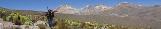
Equipment weighs only 30 kg per site, so it's portable by backpack, ATV, snowmobile, or helicopter, from tundra to jungle, in any season. This logistic simplicity reduces cost and increases productivity.
The small footprint and environmentally benign installation make the technique practical almost anywhere.
Flexible site location and offline sensitivity allow meaningful profiles to be constructed without the rigid grid of methods like seismic and IP.
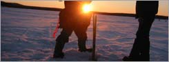
Induction vectors indicate the direction and relative strength of offline conductors and are especially useful where the surface is resistive or frozen (no electrodes required).
MT/AMT sees through the thick conductive clay (impenetrable by airborne or other surface techniques) that covers many prospective areas.